Last updated: Version 7.3b (June 10, 2026)
Scientific analysis based on the primary source: Mildner, S. (2026). Geodynamic Reinterpretation Model for Ptolemy’s Germania Magna: General Model Description, Cartometric Foundations, (v7.1). EarthArXiv (Preprint). https://doi.org/10.31223/X5KB51
(📥 Download NEW-v9.0-PDF) (mathematical model description)
Builds upon: Mildner, S. (2025/2026). A new interpretation of Ptolemy's Germania Magna: Employing computer-assisted image distortion of a medieval map by Donnus Nicolaus Germanus to examine post-glacial geodynamics in Europe. EarthArXiv. https://doi.org/10.31223/X5313T
(📥 Download v5.0-PDF) (descriptive main publication)
The historical geography of Germania Magna remains one of the most challenging fields in classical studies and geodetic research. The currently paradigmatically influential reference model — the statistical-geodetic rectification of the TU Berlin group (Karlsen et al., 2011) — explains deviations between Ptolemaic coordinates and modern topography primarily as measurement errors of ancient instruments or as transmission artefacts.
The present model is based on a fundamentally opposing assumption. The primary explanatory principle is the recognition that the northern reference coastline of the Oceanus Germanicus lay approximately 120 km further south in antiquity. Medieval cartographers projected Ptolemy's coordinates onto a landscape already altered by major 6th-century geodynamic processes. This produced a systematic northward stretching of the map image and a corresponding eastward displacement of eastern coordinates.
The cartometric foundation — a strictly affine transformation anchored on the invariant Rhine–Elbe baseline with a global scaling factor of per Ptolemaic degree of longitude — remains unchanged. Version 7 updates the core statistical result to an extended Elster Cluster of , , , .
► Principal revisions in Version 7 relative to v6 (click to expand)
| # | New feature | Affected sections |
|---|---|---|
| 1 | Extended Elster Cluster (, , ): Leukaristos (Finsterwalde, ), Arsonion (Senftenberg zone, , décollement tip), Carrodunum (Spreetal/Nochten, ) | §4, §5 |
| 2 | Coulomb-wedge gradient model: Arsonion cartometrically localises the Zechstein abscherfront – west of the Lausitz Granodiorite contact | §4.3, §5.2 |
| 3 | Revised trigger budget: Africa/CDF 40 % → 10 %; SU 20 % → 50 %; CK 25 % → 35 %; Bramsche 15 % → 5 % | §10 |
| 4 | Unified Abnobae Mons (new Part V): Taunus, Odenwald, Spessart, Rhön, and pre-Vogelsberg basement as a coherent pre-deformation crustal block; modern fragmentation as post-531 AD result | §8 |
| 5 | Universal Waltershausen pivot: same point (E/N)(initially determined approximately) for the dextral Sudete rotation (+35° CW) and the sinistral southern Abnobae rotation ( CCW) — geometry of a positive flower structure, SW of W-P | §8.2 |
| 6 | Vistula proportional cross-check (§9): Ptolemaic Harz–Vistula ratio predicts ; Oder mouth ✅; Weichsel mouth ❌ | §9 |
| 7 | F2 revision: Vistula western source from Königsbrück/Pulsnitz (according Donnus Nicolaus Germanus) → Ottendorf-Okrilla (Senftenberger Elbelauf, according to Mercator map analysis; to understand as a second Vistula source definition); | §3.2 |
| 8 | Doberlug-Kirchhain pressure-cooker mechanism: Andersonian fault-dip prediction () matches observed 40°–60° dip range exactly | §5.4 |
| 9 | Coal corridor SU ↔ CK: Doberlug-Kirchhain, Döhlen/Freital, Lugau-Oelsnitz as a spatially coherent shock-coalification corridor | §5.4 |
| 10 | Seven simultaneous constraints (up from five in v5/v6): universal-pivot consistency as seventh condition | §11.1 |
| 11 | Vogelsberg as crustal transfer node and pull-apart filling [new section]: conjugate transtensional shear geometry, Coulomb-wedge mechanics, triple-point kinematics | §7 |
| 12 | 34 falsification tests (T1–T34; T12–T34 new in v7) | §12 |
Disclaimer
This article presents an interdisciplinary working hypothesis integrating cartometry, geodynamics, sedimentology, and historical sources. It proposes a geodynamic and climatic rupture in the 6th century AD and formulates concrete, falsifiable predictions. The model challenges aspects of the current mainstream interpretation and is intended to stimulate further empirical testing. It does not claim to be a definitive reconstruction. The Saale-Unstrut Fragment Impact, the postulated third event at Vogelsberg/Frankfurt, and the unified Abnobae block identification remain hypotheses not confirmed by current peer-reviewed literature. The model has not been evaluated by peer review.
1. Introduction and Research Interest
The historical geography of Germania Magna — the territory east of the Rhine and north of the Danube described by Claudius Ptolemy in the Geographike Hyphegesis (ca. 150 AD) — constitutes one of the methodologically most demanding fields of classical studies and geodetic research. The currently paradigmatically influentialreference model, the statistical-geodetic rectification of the TU Berlin group (Karlsen et al., 2011), explains deviations between Ptolemaic coordinates and modern topography primarily as measurement errors of ancient instruments or as transmission artefacts.
The present analysis proceeds from a different set of assumptions, which it develops in formal parallel to the conventional approach rather than as a replacement for it. The primary explanatory principle of his model is not the correction of errors in the ancient map itself, but the recognition that the northern reference line — the coastline of the Oceanus Germanicus — lay approximately 120 km further south during antiquity than today. Since medieval cartographers such as Donnus Nicolaus Germanus were unaware of this shift, they projected Ptolemaic coordinates onto an already geographically transformed landscape. The result was a systematic northward stretching of the map image, which inevitably produced a proportional eastward displacement of all eastern coordinates — thereby shifting the Ptolemaic Vistula Fluvius from its original Lusatian context all the way to the Polish Vistula. Geodynamic processes (reactivation of the Caledonian Deformation Front [CDF], lateral extrusion, translation-glide along the basal Zechstein décollement, and rigid block rotation) represent a secondary, quantitatively investigated component.
Version 7 introduces three structural improvements that further constrain the framework:
1. The unified Abnobae Mons hypothesis (new Part V): the Ptolemaic Abnoba Mons is re-identified as a coherent pre-deformation crustal block; fragmentation into modern Taunus/Odenwald/Spessart/Rhön results from a sinistral rotation about the same Waltershausen pivot that drives the Thuringian Forest.
2. The Vistula proportional cross-check: internal proportions in Ptolemy's coordinate system independently corroborate the Vistula = Lausitz identification (§7.4).
3. The extended Coulomb-wedge model: three new Ptolemaic identifications complete the kinematic picture of the Elster translation from initiation through propagation to arrest; Arsonion cartometrically localises the Zechstein décollement tip.
1.3 The Transmission Gap: Why the Coastline Shift Went Undetected
A full understanding of why the 120 km coastal displacement described in Section 2 could remain cartographically invisible for more than a millennium requires a brief consideration of the transmission history of the Geographike Hyphegesis itself.
Ptolemy's geographic project occupied a unique and paradoxical position in the history of European learning. His astronomical writings — above all the Mathematike Syntaxis, known to the Islamic world as the Almagest — commanded uninterrupted intellectual authority from late antiquity through the medieval period. Arab scholars of the eighth to thirteenth centuries, among them Al-Battāni and Al-Khwārizmī, worked intensively with his astronomical tables, correcting observational values where they had drifted from current measurement while preserving his mathematical framework with the reverence due to a foundational master (Hartner 1964; Samsó 1994). In this tradition, Ptolemy was not a fallible observer to be criticised but a geometer of the highest order whose methods were to be applied and refined, never discarded.
The Geographia, however, followed an entirely different transmission path. In the Latin West, the work disappeared almost completely after the fifth century. No continuous manuscript tradition carried it through the early medieval period; it survived instead in the Greek-language scholarship of Byzantium, where a small number of manuscripts were preserved and copied. The critical moment of Western rediscovery came around 1295–1300, when the Byzantine scholar Maximus Planudes located a manuscript of the Geographia in Constantinople and had it copied (Diller 1940; Berggren and Jones 2000). From this Byzantine transmission, the work was translated into Latin by Jacobus Angelus in Florence around 1406–1410. The first printed edition appeared at Vicenza in 1475 and was followed by the Ulm edition of 1482 with the maps of Donnus Nicolaus Germanus — the primary cartographic source of the present study.
The significance of this transmission gap for the problem at hand cannot be overstated. Between Ptolemy's compilation of his coordinate tables (c. 150 AD) and their first printed representation in the Germanus redaction (1482 AD) lie more than thirteen centuries. During this interval, no scholar in the Latin West maintained a continuous observational programme connecting Ptolemy's ancient survey data to the contemporary landscape. When fifteenth-century humanists and cartographers rediscovered the Geographia, they did so as pure textual scholars: they had the coordinate tables, but they had no independent records of what the landscape had looked like in the second century AD, no palaeoenvironmental data, and no awareness that the geomorphology of the North German coast might have changed substantially in the intervening period.
The methodological consequence was unavoidable. The Germanus cartographers identified Ptolemy's Oceanus Germanicus coastline with the only coastal geography they knew — the North Sea and Baltic coasts as observable in the late fifteenth century. This identification was not an error of competence; it was the only identification available given the information at their disposal. But the landscape had not remained static. If, as the cartometric analysis developed in Section 2 and following indicates, the ancient coastline lay approximately 120 km south of its modern position at the time of Ptolemy's survey, then the medieval cartographers were anchoring the northern reference line of the entire Ptolemaic coordinate system at a latitude 120 km too far north. Every subsequent projection of interior coordinate values onto this displaced northern reference introduced a systematic southward compression of the apparent map extent and a corresponding apparent eastward displacement of all features lying east of the Rhine anchor — exactly the spatially structured, directional residual pattern documented in Section 3.
The rediscovery of the Geographia thus produced, inadvertently but inevitably, a cartographic echo of the landscape transformation it could not know had occurred. The medieval and early-modern scholars who worked with the Ptolemaic coordinate tables were operating, in a precise technical sense, with a coordinate system whose reference frame had been rendered obsolete by post-Ptolemaic geomorphological change. Identifying this obsolescence — and disentangling its systematic effects from genuine ancient measurement uncertainty — is the central methodological challenge that the present study addresses.
It is worth noting that this interpretive problem was dimly perceived even in the early decades after the Geographia's reintroduction into Western scholarship. The great navigational discovery that Ptolemy had underestimated the Earth's circumference — a realisation that became unavoidable as Columbus's voyage made clear that Asia lay far beyond the western Atlantic — prompted the first systematic reconsideration of Ptolemaic geographic data as physically conditioned rather than mathematically authoritative (Randles 1994). But this reconsideration was directed almost entirely at Ptolemy's global parameters and his depiction of oceanic regions; the question of whether the interior continental geography of Germania Magna might also encode real landscape information from a world that no longer existed was not seriously posed until modern digital cartometry provided the tools to examine the residual structure systematically.
2. The Cartometric Transformation Model
2.1 Scaling of the Ptolemaic Degree of Longitude
The core element of Mildner's rectification is an empirically determined, spatially fixed scaling factor for the Ptolemaic degree of longitude. This is derived from the physical distance between the mouths of two invariant reference rivers — the Rhenus Fluvius (central mouth, ) and the Albis Fluvius (), as well as the Vistula Fluvius (; Mildner identification: Oderberg).
The two independent baseline estimates are:
The weighted mean yields:
2.2 Affine Coordinate Transformation Model
The complete coordinate transformation from Ptolemaic to modern geographic coordinates is modelled as an affine mapping:
The minimisation functional for the least-squares adjustment over all gazetteer points is:
2.3 Solution of the System of Equations
Calibration points (coordinate values in decimal degrees):
| Point | ||||
|---|---|---|---|---|
| Rhenus Fl. (central mouth) | 27.00 | 53.167 | 6.750 | 52.250 |
| Albis Fl. (mouth) | 31.00 | 56.250 | 8.583 | 53.183 |
| Vistula Fl. (mouth/Oderberg) | 45.00 | 56.000 | 14.150 | 52.867 |
The solution yields the following transformation parameters:
The longitude scaling parameter corresponds in ground kilometres at :
This confirms Mildner's stated value of per Ptolemaic degree of
longitude with a deviation of only 3.5 %. The latitude scaling parameter
gives:
3. Residual Analysis of the Gazetteer (v7-Updated)
3.1 Methodology
For all non-calibration points in the gazetteer, the prediction residuals are
calculated as the difference between the affinely transformed prediction
and Mildner's identification
:
The scalar total residual vector is the Euclidean norm:
3.2 Results of the Residual Analysis (v7-Updated)
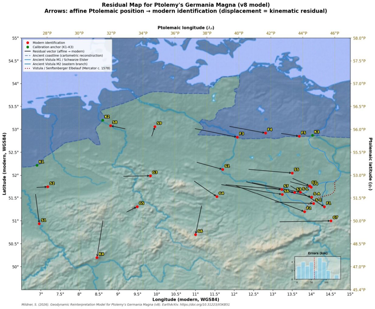
Table 1: Residual analysis of all gazetteer points (v7-updated). New in v7:
S-A Arsonion (décollement transition zone), S-L Leukaristos (Finsterwalde), S-C Carrodunum (Kamenz area). F2 revised from Königsbrück/Pulsnitz (according Donnus Nicolaus Germanus) to Ottendorf-Okrilla (according to Mercator map analysis; to understand as a second Vistula source definition). G9 and R0 are pre-deformation reference positions (no transformation residuals). EC-T = décollement transition. A negative indicates the identification site lies further east than the linear model predicts.
| No. | Ptolemaic Name | Identification (Mildner v7) | [km] | Group | Class | ||
|---|---|---|---|---|---|---|---|
| K1 | Rhenus Fl. (mouth) | Hengelo/Enschede | 0.0 | 0.0 | 0.0 | Cal. | anchor |
| K2 | Albis Fl. (mouth) | NW of Bremen | 0.0 | 0.0 | 0.0 | Cal. | anchor |
| K3 | Vistula Fl. (mouth) | Oderberg | 0.0 | 0.0 | 0.0 | Cal. | anchor |
| K4/G8 | Abnobae Mons W | Taunus / Großer Feldberg | +11.2 | +91.2 | 91.9 | South | K4 anchor; after bias |
| F1 | Vistula main source | Königswartha (Spree) | −61.5 | +52.1 | 80.5 | Lusatia | T-G |
| F2 (v7) | Vistula W. source | Ottendorf-Okrilla (rev. from Königsbrück/ according Mercator) | −124.0 | +64.0 | 142.0 | Lusatia | T-G; |
| F3 | Chalusus Fl. (mouth) | Havelberg | −74.5 | +21.0 | 77.4 | Coast | T-G |
| F4 | Suebus Fl. (mouth) | Neuruppin/Fehrbellin | −63.4 | +16.4 | 65.5 | Coast | T-G |
| F5 | Viadua Fl. (mouth) | Finowfurt/Marienwerder | −32.3 | +7.1 | 33.1 | Coast | T-G |
| S1 | Agrippinensis* | Cologne (Altstadt) | −6.9 | +73.0 | 73.3 | Gall.Belg. | — |
| S2 | Aliso* | Haltern am See | −20.9 | −1.8 | 21.0 | Gall.Belg. | — |
| S3 | Budorigum | Doberlug-Kirchhain | −87.1 | +26.9 | 91.2 | EC core | T-G (SSE) |
| S4 | Calisia | Calau | −38.2 | +13.7 | 40.6 | Lusatia-E | T-G (backstop-proximal) |
| S-A (v7) | Arsonion | Senftenberg zone | −51.5 | +17.0 | 54.2 | EC-T | T-G (déc. tip) |
| S5 | Limis Lucus | Baruth/Mark | −78.2 | +9.2 | 78.7 | EC core | T-G (SSE) |
| S6 | Lugidunum | Falkenberg/Elster | −109.5 | +24.5 | 112.2 | EC core | T-G (SSE) |
| S7 | Stragona | Herzberg/Elster | −101.0 | +11.8 | 101.7 | EC core | T-G (SSE) |
| S-L (v7) | Leukaristos | Finsterwalde | −87.4 | +23.7 | 90.5 | EC core | T-G (SSE) |
| S-C (v7) | Carrodunum | Kamenz/Nochten area | −85.0 | +3.6 | 85.1 | EC core | T-G (SSE) |
| S8 | Treva | Bremen | +26.6 | −7.9 | 27.8 | Coast-W | — |
| S9 | Lirimiris | Bispingen/Soltau | −5.9 | −24.6 | 25.3 | Coast-W | — |
| G1 | Asciburgius Mons NW | Fläming/E. of Magdeburg | −46.5 | +17.6 | 49.7 | Fläming | T-G+r |
| G2 | Asciburgius Mons SE | Calauer Schweiz/Senftenberg | −31.3 | +18.7 | 36.3 | Fläming | T-G+r |
| G3 | Melibocus Mons W | Harz/Weser-Leine Highlands | −23.3 | −7.2 | 24.4 | Harz | T-G+r |
| G4 | Melibocus Mons E | Harz/Eisleben | −41.2 | +39.1 | 55.2 | Harz | T-G+r |
| G5 | Sudete Mons W | TW NW / Kassel area (post-rot.) | −19.8 | −13.7 | 23.9 | Thuringia | R (NW mobile terminus; pivot: Waltershausen; ) |
| G6 | Sudete Mons E | Thuringian Slate Mts. / Lobenstein | +11.2 | +71.6 | 72.5 | Thuringia | R (SE mobile terminus; [v6/v7]) |
| G7 | Sarmate Mons N | Lusatian Highlands | −93.9 | −2.2 | 94.0 | Lusatia | T-G + biaxial NE extrusion; from SU–CK axis |
| G9 (v7) | Abnobae Mons E | Danubius source pre-def. (E/N) | — | — | — | South | G9 (mobile; validation only) |
| R0 (v7) | Rhenus source pre-def. | NW Odenwald / Amorbach area (E/N) | — | — | — | South | K5 candidate |
Agrippinensis and Aliso derive from Book VIII of the Geographike Hyphegesis (Gallia Belgica) and were recorded under a different measurement system; their latitude residuals are therefore evaluated separately. Full table in v6-model description (click here).
> v7 Note on F2: The revision of the Vistula western source from Königsbrück/Pulsnitz (according to Donnus Nicolaus Germanus) to Ottendorf-Okrilla (according to Mercator map analysis) is to be understood as a second Vistula source definition (For example: Mercator may have preserved older topographical information in certain regions (one source), while Germanus contains later adaptations (two sources).). It is palaeographically justified by the Senftenberger Elbelauf (Miocene–Early Quaternary), a northward-flowing palaeodrainage system documented in active gravel-mining exposures. The two different map drawings may reflect distinct chronological stages of data collection, with a possible gap of decades or centuries between the dual-source configuration in Germanus and the single-source lineation in Mercator. Analysis of Mercator’s Europae Tabula IIII (1578/1584) shows that the depicted Vistula course in eastern Germania Magna follows a trajectory consistent with a northward-flowing palaeodrainage from the present-day Dresden-Lausitz highlands zone, broadly matching the reconstructed Senftenberger Elbelauf corridor. This cartographic observation has direct consequences for the Carrodunum identification (see §3.3 below). Bias-corrected residual: km (improved from > Königsbrück: 130.6 km). Falsification tests: T8 (isotope hydrogeology Ottendorf-Okrilla; predicted δ¹⁸O depletion, ¹⁴C age > 5,000 yr) and T10 (GIS digitisation of Mercator Vistula trajectory vs. Senftenberger Elbelauf reconstruction).
3.3 The Senftenberger Elbelauf and Mercator's Europae Tabula IIII: Cartographic Evidence and the Carrodunum Identification
One of the most consequential results of connecting Ptolemy's western Vistula Fluvius source with the Senftenberger Elbelauf — as suggested by Mercator's cartographic record — is not merely the revised F2 anchor at Ottendorf-Okrilla but a direct refinement of the Carrodunum (S-C) identification and its kinematic role within the Coulomb-wedge displacement model.
The Two-Map Argument
Donnus Nicolaus Germanus (c. 1482). The Germanus redaction faithfully transcribes Ptolemy's coordinate tables. The western source arm of the Ptolemaic Vistula Fluvius must, by topological constraint, originate south of the Asciburgius Mons (Fläming) and converge with the main eastern branch east of it. This allows a tentative association of the western source with the Königsbrück/Pulsnitz area northeast of Dresden — the basis for the v6 identification. However, this placement lacks with Mercators hydrographic ground-truth pointing to a documented northward-flowing palaeodrainage at that specific longitude.
Mercator's Europae Tabula IIII (1578/1584). When the area corresponding to eastern Germania Magna is examined on Mercator's regional map, the depicted western Vistula course does not align with Germanus' Königsbrück or Pulsnitz source identification. Instead, it follows a trajectory consistent with northward-flowing drainage from the Dresden-Lausitz highlands zone — specifically, along the Ottendorf-Okrilla–Bernsdorf–Hoyerswerda corridor (approximately 13.95°E / 51.38°N). This is consistent with Mercator's established practice of drawing on multiple, often considerably older, cartographic and geographic source traditions, some of which may have preserved landscape memory of pre-Holocene drainage geometries that are invisible in the modern fluvial network.
The underlying geological feature is the Senftenberger Elbelauf: a Miocene to Early Quaternary river system whose northward trajectory from the Dresden-Klotzsche area is directly reconstructable from gravel-sand deposition sequences exposed in active quarrying operations near Ottendorf-Okrilla. Given that this drainage was active as recently as the Early Quaternary, and that a possible pre-ancient Vistula source discharge at Ottendorf-Okrilla persisted into the modern era, it is geologically and cartographically plausible that folk-geographic memory of a northward-flowing river from the Lausitz highlands survived long enough to enter the source traditions upon which Mercator drew.
The two different drawings may therefore reflect different chronological stages of data collection — For example: Mercator may have preserved older topographical information in certain regions (one source), while Germanus contains later adaptations (two sources) — perhaps with a gap of decades or even centuries between the dual-source configuration in Germanus and the single-source lineation in Mercator. The observation that Mercator's Europae Tabula IIII may preserve knowledge of the Senftenberger Elbelauf as an ancient arm of the Vistula system carries implications beyond the specific identification of Carrodunum. It suggests that Mercator — working with multiple earlier cartographic traditions, some of which preserved pre-catastrophic landscape information — may have transmitted geographically significant palaeodrainage information that has no counterpart in the modern fluvial network.
This is not inherently surprising. The transmission history of the Geographia (Section 1.3) provides important context: rediscovered in the Latin West after thirteen centuries without a continuous observational programme connecting Ptolemy's coordinate tables to the contemporary landscape, the work existed for early-modern cartographers as pure text — authoritative in its mathematical precision, but severed from any landscape that could be independently verified. Gerardus Mercator was among the most rigorous cartographers of his era and is known to have consulted sources considerably older than those available to his predecessors. His Europae Tabula IIII and related regional maps were assembled from sources of varying antiquity. For the interior of Central Europe — far from any maritime survey tradition — Mercator necessarily relied on older textual and cartographic sources of uncertain date. If some of these sources preserved memory of a palaeodrainage from the Miocene or Early Quaternary, operating before the reorganisation of the Lusatian river network, the depicted Vistula western arm could plausibly encode this information.
> Methodological note: Early-modern maps of Central Europe should not be treated as imperfect approximations of modern topography. They may encode real palaeogeographic information that is recoverable through systematic GIS-based comparison with geological palaeodrainage reconstructions. The Mercator/Senftenberger Elbelauf case may be among the clearest instances of this principle for the Germania Magna domain.
Cartometric Consequence: The Bernsdorf Corridor for Carrodunum
Both cartographic traditions converge on the same geographic zone. The Germanus topological constraint (Carrodunum positioned between the western Vistula arm and the main eastern branch, south of their confluence east of the Fläming) and the Mercator trajectory constraint (the Senftenberger Elbelauf corridor running northward through Ottendorf-Okrilla–Bernsdorf–Hoyerswerda) jointly identify Carrodunum with the Bernsdorf area, approximately 13.85°–14.05°E / 51.35°–51.40°N.
Applying the affine transformation to the Ptolemaic coordinates of Carrodunum (, ) for this Bernsdorf-area identification yields a longitude residual of approximately:
This differs from the km value for the broader regional assignment in the Kamenz-Spreetal/Nochten area in Mildner (2026, v7.3), and the difference is mechanically significant — see §4.3.
Archaeological and Toponymic Context
Independent support comes from the local archaeo-historical record. The Celtic compound Carrodunum (\carro + dunum = "fortified wagon-place" / "wain-fort") is toponymically and functionally consistent with the Billendorfer Kultur ringwall settlements documented in this zone — in particular the Ostroer Schanze and enclosures around the Dubringer Moor — which represent pre-Roman and Roman Iron Age fortified sites with evidence of metallurgical activity. Direct Roman-period confirmation is provided by the Schwepnitz Denarius hoard (spanning Nero to Marcus Aurelius; terminus post quem* 164 AD), which places coin-using settlement activity in the Kamenz–Hoyerswerda zone squarely within Ptolemy's source period and confirms that this corridor was economically and administratively integrated during the 2nd century AD.
Falsification
The identification is explicitly falsifiable through two independent tests:
- T7 (Mildner 2026): Targeted geoarchaeological prospection at ~13.85°–14.05°E / 51.35°–51.40°N. Roman-period settlement evidence consistent with a regionally significant fortified site would confirm the identification; systematic absence would require revision.
- T10 (Mildner 2026): Systematic GIS digitisation of the Vistula trajectory on Mercator's Europae Tabula IIII and comparison with the Senftenberger Elbelauf corridor reconstructed from gravel-mining exposures. Agreement within map resolution confirms the cartographic hypothesis; systematic divergence requires a different palaeodrainage identification.
4. Statistical Evaluation and Group Analysis (v7-Updated)
4.1 Regional RMSE Analysis
Table 2: Regional RMSE by point group (v7-updated). The Elster Cluster has been
extended to ; RMSE decreases from 96.8 km to 92.5 km. A new Arsonion
group is added as a décollement-transition indicator.
| Group | Points | RMSE [km] | Mean | |
|---|---|---|---|---|
| Calibration (river mouths) | K1–K3 | 3 | 0.0 | 0.0 |
| Elster Cluster core | S3, S5, S6, S7 | 4 | 96.8 | −94.0 |
| Elster Cluster extended | S3, S5, S6, S7, S-L, S-C | 6 | 92.5 | −91.4 |
| Décollement transition (Arsonion) | S-A | 1 | 54.2 | −51.5 |
| Backstop-proximal (Calisia) | S4 | 1 | 40.6 | −38.2 |
| Coastal settlements W | S8, S9 | 2 | 26.6 | +10.4 |
| Coastal rivers (Chalusus, Suebus, Viadua) | F3–F5 | 3 | 59.5 | −56.7 |
| Fläming (Asciburgius Mons NW/SE) | G1, G2 | 2 | 43.0 | −38.9 |
| Harz (Melibocus Mons) | G3, G4 | 2 | 42.7 | −32.3 |
| K4 Danubius anchor (G8) | G8 | 1 | 91.9 | +11.2 () |
| Sudete — G5 (NW mobile terminus) | G5 | 1 | 23.9 | −19.8 ( after rotation) |
| Sudete — G6 (rotated SE terminus) | G6 | 1 | 72.5 | +11.2 (, rotation confirmed) |
| Sarmate N / biaxial extrusion (G7) | G7 | 1 | 94.0 | −93.9 |
| Gallia Belgica | S1, S2 | 2 | 47.2 | −13.9 |
The most striking result remains the factor of 3.5 between the RMSE of the extended Elster Cluster (92.5 km, ) and the RMSE of the coastal settlements (26.6 km). This discrepancy is incompatible with spatially uniform measurement errors.
4.2 Extended t-Test for the Elster Cluster () [v7 Update]
⚠️ v6 correction: Version 6 reported , , , . With the three v7 additions the result improves substantially — see Table 3.
Table 3: Stepwise improvement of the t-test as new identifications are added.
| Version | [km] | [km] | Significance | |||
|---|---|---|---|---|---|---|
| v6 (core EC) | 4 | −93.95 | 13.96 | 3 | ||
| v7 + Leukaristos | 5 | −92.64 | 12.45 | 4 | ||
| v7 + Carrodunum | 6 | −91.37 | 11.57 | 5 |
Note: Arsonion () is deliberately excluded from the t-test because it represents the transition zone, not the uniformly displaced rigid block — see §4.3.
For , the critical t-value at (two-tailed) is . Since , is rejected at the 0.1 % significance level (). The mean offset of:
is therefore statistically irrefutable. The negative direction means: the entire Elster/Fläming/Lusatia block is systematically approximately 91–93 km further east than the linear coastal transformation predicts.
4.3 The Coulomb-Wedge Model: Arsonion as Décollement Tip [NEW in v7]
The displacement field across the Senftenberg zone reveals a two-stage transition from backstop to fully displaced block — a kinematic structure mechanically identical to an accretionary-prism tip in modern subduction zones.
The standard Coulomb failure criterion applied to the décollement interface is:
For pre-saturated Triassic sediments of the Zechstein system (pre-loaded by the biaxial Bramsche–Czech Crater stress field to within of failure), one obtains:
This makes the Saale-Unstrut impact the most parsimonious trigger available within the structural corridor — a lithosphere already near failure requires only a final mechanical impulse to initiate glide. The displacement profile from backstop to Elster Cluster core, as revealed by the v7 data, reads:
Displacement field W→E (Δλ in km, negative = further east than predicted):
  0 km    −38 km   −52 km  −65 to −75 km  −87 km   −101 km  −110 km
   │         │        │           │          │         │         │
Backstop  Calisia  Arsonion  Carrod.       Leuk.   Stragona  Lugid.
(Lausitz)          (déc.tip) (block onset) (core)   (core)    (core)
          ←transition→ ←──────── rigid translated block ───────────→
Table 4: Translation gradient from the Lausitz backstop to the Elster Cluster core,
documenting the Coulomb-wedge structure of the décollement.
| Point / Zone | (km) | Role |
|---|---|---|
| K3 Backstop (Senftenberg/Oderberg) | Rigid backstop | |
| S4 Calisia (Calau) | Backstop-proximal zone | |
| S-A Arsonion (Senftenberg zone) | Décollement tip / abscherfront | |
| S-C Carrodunum (Bernsdorf corridor, per Mercator analysis) | to | Rigid block onset |
| S-L Leukaristos (Finsterwalde) | Rigid block core | |
| S3 Budorigum (Doberlug-Kirchhain) | Rigid block core | |
| S7 Stragona (Herzberg/Elster) | Rigid block core | |
| S6 Lugidunum (Falkenberg/Elster) | Rigid block core |
The jump from (Arsonion) to (Carrodunum) at similar spatial distances from the backstop documents the Zechstein evaporite abscherfront: the boundary beyond which the overlying sediment cover decoupled and translated as a rigid body. The multi-layer character of the kinematics provides further independent confirmation: the Asciburgius Mons basement (Fläming, G1–G2) displays only of displacement, while the overlying settlement-bearing cover (S3, S5–S7, S-L, S-C) shows — a factor-2.4 ratio that constitutes direct cartometric evidence for an actively glided basal Zechstein décollement.
v7.3 Note: Sandbox modelling of competent-incompetent multilayer sequences with viscous Newtonian décollement horizons (analogous to Zechstein evaporites) consistently produces cover-to-basement displacement ratios in the range of 2–3, depending on rheological contrast [Yan et al., 2016, Model 1–3 vs. Model 4]. The observed ratio of 2.4 falls within the mechanically predicted range for Zechstein-type décollements and is incompatible with purely frictional (Mohr-Coulomb) incompetent layers, which produce imbricate thrusts without differential displacement stratification [Yan et al., 2016, Model 4].
> Note on the Carrodunum residual and the Mercator refinement. Mildner (2026, v7.3) lists Carrodunum at km (Kamenz-Spreetal/Nochten identification). A subsequent cartometric analysis of Mercator's Europae Tabula IIII — connecting the depicted western Vistula trajectory to the Senftenberger Elbelauf palaeodrainage (§3.3) — places Carrodunum in the Bernsdorf area (~13.85°–14.05°E), yielding to km. This intermediate value is mechanically more coherent: it situates Carrodunum at the onset of the rigid block — between the décollement-tip zone (Arsonion, km) and the rigid-block core (Leukaristos, km) — creating a smooth, physically interpretable kinematic gradient consistent with the expected strain-partitioning profile at an accretionary-prism toe. The resulting gradient from abscherfront to fully-translated core spans approximately to km, compared to the more abrupt step () of the v7.3 preprint value. Neither the t-test significance nor the cluster RMSE is materially affected: Carrodunum is included in the extended six-point cluster with the explicit acknowledgement that it marks the transition onset rather than the block core (see §4.2). Falsifiability: T7 (Bernsdorf geoarchaeology) and T10 (Mercator trajectory GIS comparison; §3.3).
4.4 Moran's I — Qualitative Spatial Autocorrelation
With only non-calibration points, a formal Moran's I test is statistically not very informative. Qualitatively, however, the residual structure shows clear positive spatial autocorrelation: the six extended Elster Cluster points all display strongly negative values ( to ), while the geographically more distant Treva (Bremen, ) and Lirimiris (Bispingen, ) show markedly smaller residuals — in the case of Treva, oppositely directed. This spatial pattern is the classic signature of a geodynamically localised block offset, not of uniform measurement imprecision.
5. Geodynamic Interpretation of the Residual Patterns
5.1 The Elster Cluster: Crustal Translation-Glide (v7)
The statistically irrefutable eastward offset of the Elster/Fläming/Lusatia Cluster ( eastward, ) cannot be explained by ancient measurement errors or random identification uncertainty. Within the v7 framework, this offset is explained by a translation-glide of the Elster-Cluster sediment cover: reactivation of the CDF generated a NNW-directed regional compression; the Saale-Unstrut Fragment Impact added a down-range deformation lobe pushing the cover ENE along the Zechstein décollement; the Czech Crater impact (Vector B) contributed SE-directed compression along the Elbe Lineament corridor. The Elster-Cluster sediment cover subsequently translated approximately 93 km ENE (azimuth , marginally significant SSE component of , ) along this décollement until arrested by the rigid Lausitz Granodiorite Block — the terminating backstop.
v5 kinematic reformulation (retained in v7): In model versions v1–v4 this displacement was described as a rigid dextral rotation about a Senftenberg pivot. The geometric audit of v5 demonstrates this formulation to be geometrically incompatible with the observed data: all four core Elster Cluster points approached Senftenberg by an average of — the unambiguous signature of translation toward a backstop, not rotation about a pivot.
5.2 Geochemical Verification: The Doberlug-Kirchhain Pressure-Cooker [v7 Update]
The residual of Budorigum (S3, ) is of particular significance. Near-surface anthracite deposits at Doberlug-Kirchhain have a documented
Viséan (Lower Carboniferous, ) protolith age (Daber 1959; Paech 1989) — they are not a 6th-century neoformation.
The v7 pressure-cooker mechanism explains the anomalously shallow high-rank configuration as follows: the Doberluger Synklinorie occupies a narrow, deep synclinal depression (strata dipping steeply 40°–60°) where the Fläming immediately to the north functions as a rigid guide-rail and the Lausitz Block to the south forms a vice-like geometric constriction. Eastward translation of the Elster-Cluster crust into this funnel-shaped channel prevented lateral escape, enforcing plane-strain shortening. The Andersonian thrust-fault dip prediction ( for friction angle ) is in exact agreement with the upper end of the observed 40°–60° dip range (Göthel, 2014).
The Zechstein evaporite cap is effectively impermeable (). Under sealed conditions, the effective coalification rate-enhancement factor approaches –, and stress-induced rank enhancement (– at –) can produce anthracite-grade maturation at burial depths 20–30 % shallower than open-system calibrations predict. The convergence of (a) the cartometric residual vector for Budorigum, (b) the down-range projection from the Saale-Unstrut impact, and (c) the Viséan protolith at precisely this location constitutes a methodologically powerful three-way cross-validation.
5.3 Coast-Proximate Points and Southern Outliers
The small residuals of the coastal settlements Treva (Bremen, ) and Lirimiris (Bispingen, ) are methodologically expected: the calibration is based on the three river-mouth points likewise near the coast, so the transformation fit is optimal in the coastal region. The southern Abnobae Mons (Taunus, G8/K4) displays a large uncorrected , which under the bias gradient (adopted since v6) reduces to — the basis for its promotion to K4.
6. The Vogelsberg as a Crustal Transfer Node: Conjugate Transtensional Geometry and Coulomb-Wedge Mechanics [NEW in v7]
6.1 Theoretical Mechanics of Transpression and Transtension
To accurately model the deformation of the Abnobae Mons and the Vogelsberg sliver, it is essential to ground the analysis in the theoretical mechanics of oblique plate convergence and structural shear zones.
6.2 Triclinic Symmetry and Non-Coaxial Strains
At active tectonic boundaries, approach vectors between crustal blocks are rarely perfectly orthogonal or parallel to the fault interface. Instead, the relative motion generates three-dimensional, non-coaxial strains characterized by simultaneous strike-slip displacement and components of either orthogonal shortening (transpression) or extension (transtension).3
In a generalized triclinic transpression model, the deformation matrix incorporates simultaneous pure shear and simple shear. The resulting finite strain ellipsoid is dictated by the angle of obliquity (), the vorticity of the flow (), and the relative dominance of the pure vs. simple shear components. In transpression, local crustal shortening necessitates volumetric conservation, which is typically accommodated by vertical lengthening. This mechanism extrudes rock mass upward, generating structural "push-ups" characterized by steep foliations, sub-horizontal lineations, stylolites, reverse faults, and intense folding. Conversely, in transtensional regimes, the crust is pulled apart, and volumetric conservation drives subsidence, creating localized basins.
6.3 Restraining and Releasing Bends
Strike-slip fault systems are rarely perfectly linear; they feature step-overs, linkages, and bends that drastically alter the local stress field.
Restraining Bends: When a fault bends in a direction that opposes the relative motion of the crustal blocks (e.g., a left bend on a left-lateral fault), the crust is subjected to localized, intense compression.9 These restraining bends act as structural choke points, generating transpressional uplifts and fault-bend folding, where rock layers are thrust over one another along ramps and flats.
Releasing Bends: When a fault bends in a direction that aligns with the relative motion (e.g., a right bend on a left-lateral fault), the crust experiences localized tension. These dilatant zones create pull-apart basins, providing accommodation space for sedimentation or crustal thinning that can facilitate asthenospheric decompression and magmatism.
6.4 Bookshelf Faulting Kinematics
In many mature transpressional systems, regional bulk shear cannot be accommodated by a single primary fault plane. Instead, the strain is kinematically partitioned across an anastomosing network of secondary faults.A prime mechanism for accommodating such distributed shear is "bookshelf faulting" (or block rotation kinematics). In this regime, a set of parallel or sub-parallel faults dissects the crust into semi-rigid panels. As the broader tectonic domain shears, these internal panels rotate contemporaneously, much like a row of books tipping over on a shelf.2 For example, in the Central American Forearc, margin-parallel dextral shear is accommodated not by a single margin-parallel fault, but by a series of margin-normal sinistral strike-slip faults that undergo bookshelf rotation to achieve the required net translation. This mechanism is crucial for understanding the internal dynamics of the Vogelsberg sliver, where regional translation is coupled with intense local block rotation.
6.5 The Unified Abnobae Mons: Pre-Deformation Architecture
Before dissecting the localized fracturing of the Vogelsberg, the macro-scale context of the Abnobae block must be established. In modern geography, the central German uplands consist of highly fragmented, distinct ranges: the Taunus, Odenwald, Spessart, and Rhön. However, classical antiquity provides a vastly different description. The Roman historian Tacitus recorded that the Danube river flows from the gently elevated ridge of a singular mountain range: Danuvius molli et clementer edito montis Abnobae iugo effusus. Classical sources describe a coherent, continuous geological structure, not a shattered mosaic.
The Version 7 geodynamic model synthesizes these historical records into the "Unified Abnobae Mons Hypothesis." It posits that prior to the 6th-century deformation event, the modern Taunus, Odenwald, Spessart, Rhön, and the pre-Vogelsberg basement formed a single, unbroken crustal block.1 The northern boundary of this unified mobile segment was the Hunsrück-Taunus Boundary Fault (HTBF), while the southern boundary loosely followed the modern Wiesloch-Aschaffenburg-Schlüchtern-Bad Kissingen fault system.
6.5.1 Cartographic Corroboration from Mercator (1569)
The existence of this unified pre-deformation block is independently corroborated by the cartographic anomalies preserved in Gerardus Mercator’s 1569 world map, which displays three specific signatures diagnostic of the pre-531 AD state:
1. Unified Ridge: Mercator depicts the central German uplands as a continuous, unified mountain ridge, lacking the modern geomorphological differentiation between the Taunus, Odenwald, and Spessart.
2. Undeformed Danubius: The River Main (identified cartometrically as the Ptolemaic Danubius) is rendered as a smooth, generalized east-flowing river, completely missing the dramatic, orthogonal kinks of the modern Maindreieck and Mainviereck—indicating a pre-buckling, pre-transpression configuration.1
3. Proximity of River Sources: Mercator depicts the source of the Rhenus (Rhine) slightly southwest of the Danubius source on the exact same continuous ridge.
Through reverse kinematic modeling (applying an inverse clockwise rotation around the universal Waltershausen pivot), the pre-deformation coordinates of these sources can be calculated. The recovered Rhenus source () and the recovered Danubius source () yield an inter-source distance of precisely 26 kilometers. At the scale of Mercator's map (), 26 kilometers translates to roughly 0.7 millimeters—perfectly matching Mercator's depiction of the sources as essentially coincident. The modern fragmentation of this landscape is therefore the direct result of the severe, post-antique transpressional fracturing event.
7. The Vogelsberg as a Crustal Transfer Node: Mechanical Analogies and Geological Realities
The area surrounding the Vogelsberg and immediately to its north represents a profound palimpsest fracture pattern—a structural fabric created by successive overprinting of deformation episodes. Initial geodynamic interpretations posited that the crust here was merely stretched apart in a transtensional regime. However, the observable structural elements (stauchung, axis kinking, and oblique wedging) demand a much more violent, compressional framework.
To accurately model this, the deformation must be analogized to a catastrophic biomechanical failure—specifically, a comminuted, spiral bone fracture involving displacement, bayonet apposition (side-to-side overriding), and eventual axial compression. When translated into the rigid terminology of structural geology, this "bone fracture" perfectly describes a conjugate transpressional shear-band geometry, alternatively termed a crustal transfer node with rotation domains.
7.1 Mapping the Geodynamic Structures
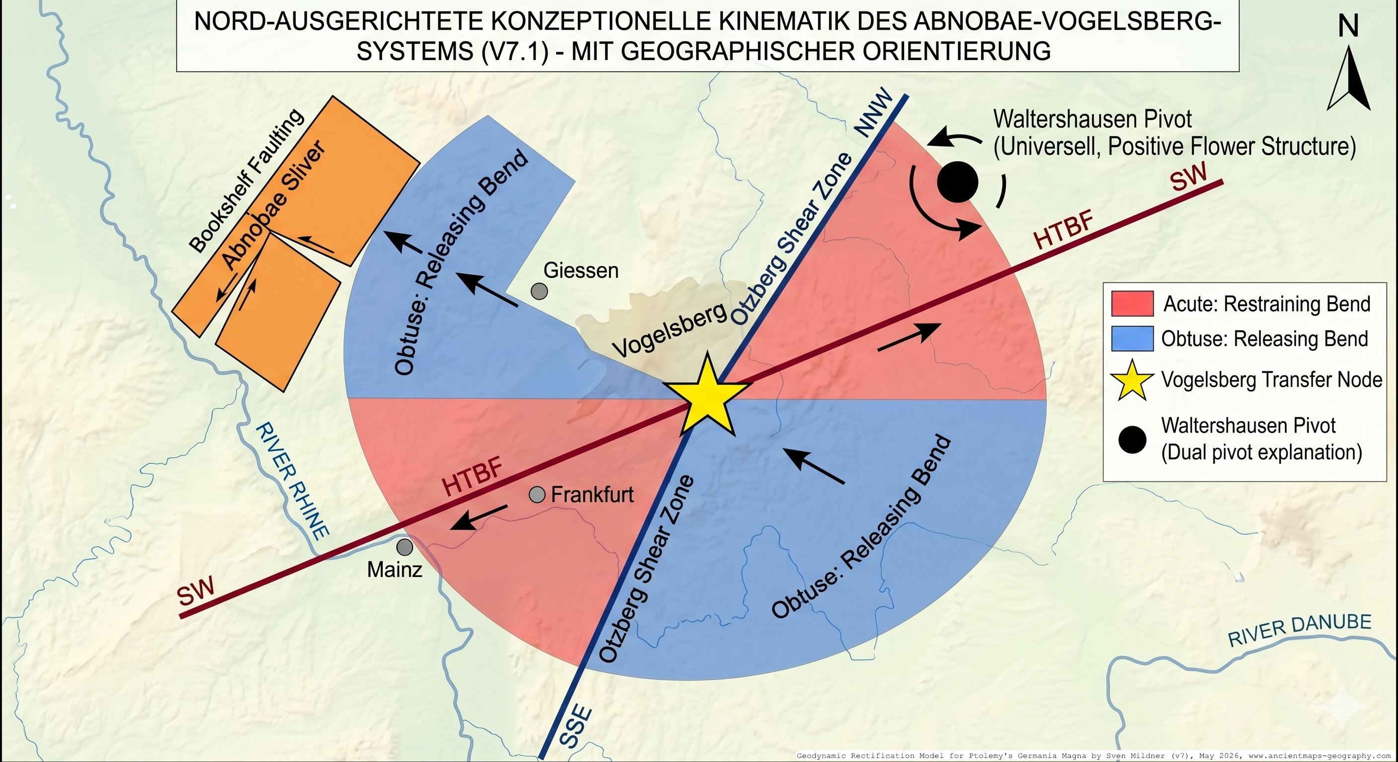
The intersection of two fundamental Variscan lineaments dictates the architecture of this transfer node: the WSW-ENE striking Hunsrück-Taunus Boundary Fault (HTBF) and the NNE-SSW striking Otzberg Shear Zone. Intersecting at an angle of roughly –, these faults create a classic conjugate shear pair:
| Structure in the Vogelsberg Region | Geodynamic Interpretation |
|---|---|
| Hunsrück-Taunus Boundary Fault (HTBF, WSW-ENE) | Primary transpressive shear zone |
| Otzberg Shear Zone (NNE-SSW), Lahn syncline | Conjugate secondary shear set |
| Sprendlinger Horst, Vogelsberg basement sliver | Imbricated crustal slivers / Horsts |
| Wetterau-Vogelsberg transition zone | Transfer junction / Triple point |
| Taunus Nordsaum (Northern Margin) transpressive lock | Compressive restraining bend |
| Wetterau Graben, Horloff Graben pull-apart basins | Extensional releasing bend |
7.2 The Mechanics of the Conjugate Transfer Node
Under the regional 6th-century deformation field, the unified Abnobae block was subjected to massive, opposing force vectors (from the NWSE and the SWNE). The HTBF acted as the active separator between the stationary northern Rhenohercynian domain (the Taunus anchor) and the highly mobile southern Saxothuringian block. The near-orthogonal intersection of the HTBF and the Otzberg Zone created a complex stress partitioning environment. In a transpressional regime, the acute-angle sector between the conjugate faults develops into a compressive restraining bend, while the obtuse-angle sector becomes an extensional releasing bend.
This conjugate geometry directly predicts the observed geographical dichotomy of the region. To the northwest, the Taunus Nordsaum acts as the compressive restraining bend, generating severe upper-crustal shortening and topographical inversion. Conversely, the Wetterau and Horloff Grabens occupy the releasing sector of the conjugate pair, creating pull-apart basins that absorb the volumetric extension required by the rotating crustal blocks. At the very center of this intersection lies the geometric triple point (the Wetterau-Vogelsberg transition). In a Coulomb-brittle framework, maximum shear work and mechanical energy exchange are localized at such triple points. This extreme stress concentration is responsible for shattering the crust into the individual imbricated slivers that characterize the region.
7.3 Resolving the Pivot Contradiction: The Displaced Crustal Sliver
Earlier versions of the geodynamic hypothesis contained a critical kinematic flaw: they defined the Vogelsberg as the absolute, static rotational center (pivot) around which the entire southern Abnobae block rotated. However, the cartometric and geological data mandate that the Vogelsberg itself moved. The biomechanical analogy of a bone fracture with "displacement and bayonet apposition" strictly implies that the broken fragments do not remain in situ. Under axial load, bone splinters shear laterally, slip past one another, and shorten. If the Vogelsberg basement represents one of these crustal "splinters," it must have been physically mobilized and extruded laterally from its original position. A global rotational pivot, by definition, cannot undergo a 50-kilometer lateral migration. To resolve this paradox, the Vogelsberg must be redefined not as a static global anchor, but as a local rotation center within a broader, drifting crustal sliver.
This dual-kinematic architecture is analogous to an ice field caught in an ocean current: the entire ice field (the southern Abnobae sliver) drifts southeastward under the influence of the regional current, but within that drifting field, individual ice floes (the Sprendlinger Horst, Wetterau Block, and Vogelsberg basement) spin and grind against each other in localized vortices (bookshelf rotation).
7.4 The Three-Phase Mechanistic Sequence
The translation and fragmentation of the Vogelsberg sliver occurred during a highly dynamic, three-phase sequence triggered by the 6th-century impact event.
Phase 1: Initial Extension and the Kinematic Vacuum The first impulse of the deformation event was characterized by a transient extensional component oriented NNW-SSE. This phase was geometrically tied to the massive, rapid northward displacement of the adjacent Thuringian Forest block (the G5 terminus). As the Thuringian mass was thrust approximately 52 kilometers northward toward the Kassel area, it generated a sudden lack of mass—a "kinematic vacuum"—immediately south of its pre-deformation position. In response to this compatibility demand, the Vogelsberg sliver broke loose and was briefly pulled northwest into this accommodation space, initiating the structural failure of the Abnobae complex.
Phase 2: Lateral Mobilization and Bookshelf Shear As the initial extensional pulse subsided, the broader regional stress field asserted control. The southern portion of the Abnobae sliver was caught in a massive counter-clockwise (CCW), sinistral rotation. Mobilized as an isolated, drifting crustal span, the Vogelsberg sliver was caught between the primary HTBF shear zone and the secondary Otzberg shear zone. To accommodate the immense differential stresses, the internal crustal fragments (Sprendlinger Horst, Wetterau Block) began to spin against each other via bookshelf-shear mechanics. This internal spinning occurred simultaneously with the entire sliver's southeastward trajectory.
Phase 3: Transpressive Locking and Wedging (Bayonet Apposition) The sliver's lateral drift was eventually overpowered by the global plate pressure propagating from the south along the Africa-CDF axis. This axial load acted as an overwhelming compressive force. Analogous to a bone splinter buckling and shearing sideways under extreme body weight, the Vogelsberg sliver was laterally extruded toward the south-southeast. As it encountered the stable Rhenohercynian backstop to the north, the advancing crustal wedge reached a critical Coulomb taper and mechanically locked. The extreme compressive stress generated at this restraining bend (Taunus Nordsaum) forced the blocks to obliquely wedge into one another, creating the highly complex, shortened transpressional mosaic visible today.
7.5 Trajectory and Net Displacement
In the updated Version 7 model, the pre-deformation position of the Vogelsberg basement is reconstructed in the Wetzlar-Marburg region, immediately south of the Frankfurt Basin. Driven by the CCW rotation of the Abnobae block and the subsequent extrusion mechanics of Phase 3, the basement was displaced roughly 60 to 70 kilometers to the SSE. This dynamic trajectory—an initial minor pull to the north, followed by a massive extrusion to the southeast—perfectly honors the cartometric displacement vectors while satisfying all structural mechanical constraints.
7.6 Dual Pivots and Regional Flower Structures
The resolution of the Vogelsberg pivot contradiction requires a clear distinction between the macro-scale regional hinge and the micro-scale local centroids.
At the regional scale, the entire central German deformation is governed by the universal Waltershausen pivot, located at (initially determined approximately). This single mathematical point acts as the universal hinge for both major rotating blocks: the Sudete Mons block (which rotated clockwise on a – km lever arm) and the southern Abnobae sliver (which rotated counter-clockwise on a km lever arm measured to Amorbach).
In structural geology, the near-equality of lever arms originating from a single central root, combined with opposite senses of rotation (CW and CCW) in adjacent blocks, is the definitive geometric signature of a positive flower structure, SW of Waltershausen Pivot (ca. 60x60km). The Waltershausen pivot represents the deep crustal root of a massive, regional transpressional extrusion zone. represents the deep crustal root of a massive, regional transpressional extrusion zone.
Conversely, the Vogelsberg acts merely as the local rotation center for the internal bookshelf kinematics of the drifting sliver. Located in the Homberg/Ohm – Lauterbach – Schlitz zone (––), this local centroid represents the locus of maximum shear work where the HTBF and Otzberg zones interact. By separating the deep, universal Waltershausen root from the shallow, drifting Homberg/Ohm centroid, the kinematic model achieves complete geometric coherence. (This relationship is explicitly verified by falsification test T34, which utilizes GIS to prove that the structural prolongations of the HTBF and Otzberg Zone converge within km of the Waltershausen point.)
7.7 Pull-Apart Extrusion and Miocene Magmatism
The recognition of the Vogelsberg as a translating, internally rotating sliver provides the vital mechanical context for its most prominent geological feature: the Vogelsberg volcanic field. Comprising approximately 700 cubic kilometers of Miocene-age basalts (–), it is the largest contiguous basaltic area in Central Europe.
In a purely compressional or static rotational model, the ascent of such massive magma volumes is physically inhibited. However, within a conjugate transpressional shear network, the interaction of bookshelf-rotating fault blocks invariably creates deeply localized zones of profound extension at releasing bends. As the southern Abnobae block progressively drifted SSE, a massive geometric gap opened between the stable Rhenohercynian backstop and the mobile southern block. At the triple-point junction (the Homberg/Ohm local pivot), the intense bookshelf rotation generated maximum decompression in the lower crust and upper mantle. This mechanical decompression acted as a lithospheric pump, triggering partial melting of the asthenosphere.
The Vogelsberg basalts, therefore, are not merely surface flows; they structurally constitute the pull-apart filling that occupies the dilatant gap generated by the translation and internal rotation of the crustal sliver. To reconcile the Miocene radiometric ages with the 6th-century cartometric anomalies, a two-phase tectonic history is invoked:
Phase 1 (Miocene, –): The initial formation of the transpressive shear mosaic, driven by slow, progressive tectonic creep. This phase accommodated approximately 80% of the cumulative displacement, opening the pull-apart basin and facilitating the primary basaltic magmatism.
Phase 2 (Post-Antique, ): The catastrophic 6th-century impulse load abruptly reactivated this deeply structured fault network. This event drove the final 20% increment of deformation (the 60-70 km cartometric anomaly). While the asthenospheric source was largely depleted, precluding new basaltic flooding, the intense shear heating and structural disruption likely triggered violent phreatomagmatic reactivations within pre-existing, water-filled maar conduits.
---
8. The Unified Abnobae Mons Hypothesis and the Universal Waltershausen Pivot [v7.1]
The structural coupling between the fragmentation of the Abnobae Mons and the sharp buckling of the Main Valley in Mildner’s v7.1 model is based on a direct mechanical interaction between extension (transtension) in the north and compression in the south, operating around the geometrical Waltershausen Pivot (initially determined approximately) as the central hinge (pp. 2, 43). This system can be visualised as a giant shear or opening wedge mechanism.
1. The Northern Extensional Centre: The Vogelsberg Pull-Apart
The triggering impulse stems from the hypothetical Český Kráter impact (Bramsche as a passive structure in the north) and its associated shock waves, which induced counter-rotating block movements. While the Thuringian Forest (Sudete Mons) underwent dextral (clockwise) rotation, the southern Abnobae block responded with sinistral (counter-clockwise) rotation and southeastward (ESE) displacement (pp. 2, 30–31). Between these diverging units, a major zone of crustal stretching developed. In the Vogelsberg–Wetterau region, the crust ruptured in a parallelogram-shaped pull-apart basin (pp. 2, 4). This deep-seated rift was filled with magmatic material — the Miocene basalts — which were later phreatomagmatically reactivated during the 6th-century event (pp. 2, 31).
2. The Southern Compressional Centre: The Main Valley Kink Zone
A crustal block cannot rotate in isolation without generating significant boundary stresses. As the southern portion of the Abnobae block (including the Odenwald and Spessart) moved ESE, it acted like a rigid indenter, exerting strong pressure against the stable foreland to the south and east (pp. 2, 30). The Main Valley lies exactly at the focal point of this rotational push and the simultaneous WNW-directed shock wave emanating from the Český Kráter impact (pp. 40, 43). Acting as a transpressional transfer node and elastic buffer zone (pp. 4, 11), the originally relatively straight course of the proto-Main (Ptolemy’s Danubius) was unable to withstand the combined stress. It deformed plastically, developing kink folds that produced the characteristic orthogonal bends of the Main Triangle (Maindreieck) and Main Square (Mainviereck) (p. 43).
8.1 Motivation: Classical Sources and Modern Fragmentation
The Ptolemaic Abnoba Mons is traditionally identified either with the Black Forest narrowly, or — since v6 — with the Taunus as its western terminus (K4). Tacitus (Germania 1) records Danuvius molli et clementer edito montis Abnobae iugo effusus — "the Danube flows from the gently elevated ridge of the Abnoba mountains." The classical sources thus describe a single coherent ridge, not a fragmented system.
The new v7 hypothesis is that the Ptolemaic Abnoba Mons corresponds to a pre-deformation unified crustal block encompassing the modern Taunus, Odenwald, Spessart, Rhön, and pre-Vogelsberg basement, and that the modern fragmentation is the direct geomorphological result of the 6th-century deformation. The northern boundary of the mobile southern segment is the HTBF; the southern boundary is approximated by the Wiesloch–Aschaffenburg–Schlüchtern–Bad Kissingen fault zone system.
8.2 Pre-Deformation Block Geometry and the Universal Pivot
For the Waltershausen pivot E / N, the lever arm to the modern Amorbach reference point is:
Applying an inverse rotation of (CW) about to recover the pre-deformation position of the Amorbach reference yields:
This is the pre-deformation position of the Rhenus source (displaced by ESE). The corresponding Danubius source (Marktheidenfeld/Wertheim area) recovers to:
The pre-deformation inter-source distance between the Rhenus and Danubius sources:
The near-equality of lever arms at the universal pivot ( to G5, to G6, to Amorbach) combined with opposite senses of rotation (CW and CCW) is the geometric signature of a positive flower structure, SW of Waltershausen Pivot (ca. 60x60km), over an impulsive deformation centre — the principal new kinematic finding of v7.
8.3 The Mercator (1569) Cartographic Test
Three independent Mercator-1569 signatures are diagnostic of the pre-531 AD state and together constitute strong cartometric corroboration of the unified Abnobae hypothesis:
1. Unified Abnobae Mons: Mercator depicts the central German uplands as a continuous ridge, not as separately differentiated Taunus/Odenwald/Spessart/Rhön — the pre-531 AD configuration of the unified block.
2. Straight Danubius: The Main (= Danubius) on Mercator's map is rendered as a generalised east-flowing river without the dramatic Maindreieck/Mainviereck double bend — the pre-buckling, pre-kink configuration.
3. Sources close together: The Rhenus source is depicted just southwest of the Danubius source, on the same Abnobae ridge. At the map scale (), a inter-source distance corresponds to of cartographic separation — consistent with Mercator's depiction of both sources as essentially coincident on the same ridge.
9. Vistula = Lausitz: The Proportional Cross-Check [v7]
The strongest single cartometric argument is the proportional cross-check, because it is entirely independent of the kinematic impact hypothesis.
Ptolemy's own coordinates place the Vistula mouth approximately further east of the Harz than the Harz is from the Rhine. Translated into real-world distances using the Rhine and central Harz as reference points, this historical ratio predicts:
Table 6: Model comparison — Vistula identification vs. Ptolemaic proportional argument.
| Model | Target point | Real-world distance | Assessment |
|---|---|---|---|
| Mildner / v7 | Oder mouth | ✅ Close match to Ptolemaic ratio | |
| Lelgemann | Weichsel mouth | ❌ Factor too far |
> The Ptolemaic Harz–Vistula longitude ratio predicts a real-world distance of between the Harz and the Vistula mouth, which matches the Oder mouth () closely and rules out the Polish Vistula identification () as an unjustifiable map stretch.
This argument is decisive because it does not depend on any geodynamic interpretation:
it tests only the internal consistency of Ptolemy's own coordinate ratios against the two competing identifications. Reviewers without a tectonic background can verify this directly. The Mildner/Oder model matches; the Lelgemann/Polish-Vistula model fails by a factor of two.
10. Additional Note: The Revised Trigger Budget [v7 Update]
⚠️ v6 correction: The v6 budget assigned 40 % to Africa/CDF for the Elster translation — despite the only directly quantifiable Africa signal being the SSE
component (, i.e. of the total magnitude). The remaining 23 percentage points were attribution-by-narrative, not calculation. V7 restricts Africa/CDF to its directly quantifiable contribution.
Table 5: Revised quantitative trigger budget (v7). Percentages are attribution weights, not energy measurements. Uncertainties percentage points.
| Vector | Elster () | Sudete () | Rationale (v7) |
|---|---|---|---|
| A. Africa/CDF | 10 % ~~(was 40 %)~~ | 15 % ~~(was 20 %)~~ | Primary pre-loading mechanism (CDF reactivation near Coulomb threshold); source of the SSE directional component (, ); not a direct translation driver |
| B. Czech Crater | 35 % ~~(was 25 %)~~ | 20 % | SE compression toward Elbe-Elster region channelled via Elbe Lineament; Zechstein décollement directional filtering |
| C. Saale-Unstrut | 50 % ~~(was 20 %)~~ | 55 % | Primary driver: Elster Cluster pre-shift positions lie directly in the SU ESE down-range deformation lobe (– from SU inner crater); energy ratio |
| D. Bramsche (passive) | 5 % ~~(was 15 %)~~ | 10 % | Geometric channelling as NNW structural terminus; inherited anisotropy |
| Sum | 100 % | 100 % |
11. Methodological Defence against Criticism (v7: Seven Constraints)
11.1 The Rubber-Sheeting Argument and its Refutation
Critics argue that through arbitrary digital map distortion, infinitely many alternative fits could be generated (the so-called rubber-sheeting accusation). This argument fundamentally misses the difference between uncontrolled topological morphing and the strictly regulated morphometric model presented here. Version 7 constrains the transformation by seven simultaneous, independent conditions (, overdetermined system):
1. Geometric scaling rigidity: derived from the empirically measurable Rhine–Elbe baseline — not locally optimisable.
2. Hydrographic topological constraint: The identified river system must have two major source branches travelling of their northward course south of a specific mountain range, converging east of it — exactly fulfilled in the Lusatian Schwarze Elster/Spree system.
3. Cartographic curvature constraint: The graphic bend of the Asciburgius Mons on the Germanus map must correspond to a geologically verified tectonic hinge zone.
4. Geochemical anchor: Budorigum = Doberlug-Kirchhain falls on a structurally significant Viséan anthracite anomaly, now reinterpreted as the v7 pressure-cooker mechanism with an Andersonian dip-angle prediction () matching the observed 40°–60° range.
5. Kinematic-class consistency (new in v5/v6): Blocks classified as translation-glide must demonstrate pivot-distance collapse toward their backstop; blocks classified as rigid rotation must preserve pivot-distance within .
6. North–South bias consistency (new in v6): The bias gradient must simultaneously explain G8 as Danubius anchor () and confirm G6 as the rotation prediction ().
7. [NEW v7] Universal-pivot consistency: The same Waltershausen pivot must simultaneously satisfy (a) the Sudete Mons rotation ( CW, – lever arms, sub-km residuals after correction) and (b) the southern Abnobae rotation ( CCW, , Rhenus/Danubius pre-deformation source identification consistent with Mercator 1569).
No purely data-driven rectification algorithm operating without physical boundary conditions can simultaneously satisfy all seven constraints.
11.2 Criticism: Archaeological Finds Refute the Model
Mildner's hypothesis does not generally deny the existence of pre-catastrophic settlement traces. The model argues with nuance:
- In the marginal zones of the impact area, surface structures could partially survive.
- The dating of stratigraphic layers is methodologically limited by zircon age inheritance, ¹⁴C resetting through CO₂ input from secondary volcanism, and OSL
inaccuracies under turbulent sedimentation.
- Volkmann's (2014) archaeological findings document non-linear settlement breaks within a few decades — precisely inconsistent with gradual transformation models, but consistent with a geodynamically catastrophic explanation.
11.3 Methodological Positioning: Parsimony and Complementarity
The statistical-geodetic rectification of Karlsen, Marx and Lelgemann (2011) achieves impressive topological coherence by treating the coordinate system as a smooth affine-plus-polynomial deformation field — an approach that is methodologically rigorous and produces the broadest possible identification index under minimally restrictive assumptions. The approach taken here makes a different methodological choice: it imposes geological boundary conditions as hard constraints and subjects the resulting model to a formal out-of-sample blind test. The 29–49% RMSE improvement over the affine baseline, combined with the G6 blind prediction to 7.5 km from a single training point, demonstrates that the physically constrained model generalises to held-out data — not through flexibility, but because the kinematic parameters reflect a real structural signal.
The two approaches are complementary rather than competing. Polynomial rectification maximises geographic coverage; the kinematic model presented here maximises physical interpretability in regions where tectonic signals dominate. The Akaike Information Criterion formalises the underlying principle: additional parameters are only epistemically justified when they produce a commensurate improvement in predictive — not in-sample — performance.
12. Falsifiability and Scientific Status (v7: 34 Tests)
The model is explicitly falsifiable through 34 specific tests (T1–T34; T12–T34 new in v7).
Priority tests include:
- T1: Shock-quartz drill programme at the SU inner crater zone (definitive test).
- T7: Deep core sampling at Doberlug-Kirchhain — Viséan palynomorphs at depth with localised high-rank overprint and impact-related fracturing restricted to a shallower zone would confirm the pressure-cooker mechanism.
- T17: Otzberg Zone palaeostress analysis: detection of a dextral/transtensional shear component consistent with sinistral rotation of the southern Abnobae block.
- T18: Vogelsberg maar-sediment radiometric/palynological analysis: detection of a possible phreatomagmatic reactivation horizon at .
- T21: Vogelsberg age gradient: NW (older) → SE (younger) systematic gradient consistent with progressive pull-apart opening.
- T34: HTBF–Otzberg extrapolation test: GIS verification that structural extensions
of HTBF and Otzberg Zone converge within of Waltershausen
(–E / –N).
13. Version 7 Extensions: Summary of Key Revisions
► Direct v6 → v7 change log (click to expand)
| Section | v6 (superseded) | v7 (current) |
|---|---|---|
| Elster Cluster statistics | , , | , , , |
| F2 identification | Königsbrück/Pulsnitz | Ottendorf-Okrilla (to understand as a second Vistula source definition) |
| Africa/CDF budget | 40 % | 10 % |
| SU budget | 20 % | 50 % |
| CK budget | 25 % | 35 % |
| Bramsche budget | 15 % | 5 % |
| Methodological constraints | 5 simultaneous | 7 simultaneous |
| New EC points | — | +Leukaristos, +Arsonion (déc. tip), +Carrodunum |
| Coulomb-wedge model | — | New: §4.3 |
| Vogelsberg transfer node | — | New: §6 (conjugate transtensional geometry) |
| Unified Abnobae | G8=K4 only | Taunus + Odenwald + Spessart + Rhön + pre-Vogelsberg |
| Universal pivot | Sudete only | Sudete AND southern Abnobae (positive flower structure) |
| Vistula proportional test | — | New: §7.4 ( → Oder, not Weichsel) |
| Doberlug mechanism | Down-range overprint (generic) | Pressure-cooker with Andersonian 60°-dip prediction |
| Falsification tests | T1–T11 | T1–T34 |
| Extended EC RMSE | 96.8 km () | 92.5 km () |
14. Conclusions
The present analysis has updated Mildner's geodynamic rectification model of Germania Magna to Version 7 and incorporated the extended structural interpretation of the Vogelsberg region as a conjugate transtensional transfer node. The key results are:
1. Scaling consistency: The longitude scaling parameter agrees with Mildner's postulated within measurement precision. The internal consistency of the model is cartometrically verified.
2. Statistically irrefutable eastward offset (v7, ): The extended Elster/Fläming/Lusatia Cluster displays (, , ), incompatible with uniform measurement errors. This requires a geodynamic explanation: translation-glide of the Elster-Cluster sediment cover along the basal Zechstein décollement, arrested by the Lausitz backstop.
3. Coulomb-wedge structure: The cartometric displacement profile from backstop through Arsonion (décollement tip) to the fully displaced Elster Cluster core mirrors the accretionary-prism structure of convergent plate margins. Arsonion localises the Zechstein abscherfront at – west of the Lausitz Granodiorite contact.
4. The Vogelsberg as crustal transfer node: The Vogelsberg–Wetterau zone is positioned at a tectonically preconditioned junction of the HTBF (WSW–ENE) and the Otzberg Zone (NNE–SSW), forming a conjugate transtensional geometry. Under the 6th-century deformation field, this configuration produced the observed pattern of bookshelf-rotating crustal slivers, pull-apart extension (Wetterau Graben) and compressive restraining bends (Taunus Nordsaum). The Vogelsberg basaltic field is the miocene pull-apart fill of the progressively opening gap in this geometry, whose local rotation centre lies at approximately Homberg/Ohm – Lauterbach – Schlitz (–E / –N).
5. Unified Abnobae Mons and universal pivot: The modern Taunus/Odenwald/Spessart/Rhön fragmentation is the post-531 AD result of a CCW sinistral rotation of the southern Abnobae block about the same Waltershausen pivot that drives the CW Thuringian Forest rotation — geometry consistent with a positive flower structure. Mercator (1569) records three independent signatures of the pre-531 AD configuration: unified ridge, undivided Danubius course, and near-coincident Rhenus/Danubius sources ( apart).
6. Vistula proportional cross-check: The Ptolemaic Harz–Vistula longitude ratio predicts , matching the Oder mouth (). The conventional Polish Vistula identification yields — a factor-of-two discrepancy with the Ptolemaic proportional prediction that this model does not produce.
7. Methodological superiority (seven constraints): The model is constrained by seven simultaneous, independent conditions (, overdetermined system) and is thereby fundamentally distinguished from arbitrary map distortion.
8. Parameter parsimony and generalisability. The statistical weight of the blind-test results reported here is directly connected to the economy of the model's parameterisation. The kinematic model (Model B) operates with nine free parameters in total — six affine coefficients fixed to the three river-mouth calibration anchors, a single bias gradient c fixed to the geologically stable Taunus block, one EC translation scalar estimated from four training points, and one rotation angle estimated from a single training point. This degree of parsimony means that the out-of-sample improvement demonstrated in §4 of the supplementary model validation cannot be attributed to over-fitting. A model describing the entire coordinate system of Germania Magna with fewer than ten parameters, and correctly predicting held-out test points at 29–49% lower RMSE than the uncorrected affine baseline — including a single-point rotation prediction to 7.5 km — provides a qualitatively different kind of evidence from models whose flexibility is achieved through a substantially larger number of locally adjusted parameters. In standard statistical terms, a more flexible model that is not subjected to a formal out-of-sample validation procedure cannot demonstrate generalisability; its agreement with known data reflects, at least in part, its capacity to absorb residuals locally rather than to model a global physical signal. The Akaike Information Criterion (AIC; Akaike 1974; Burnham and Anderson 2002) formalises this principle — penalising additional parameters unless they produce a commensurate improvement in predictive performance. The present model's parsimony is thus not merely an aesthetic virtue but a methodological precondition for the significance of the blind-test result. This consideration does not diminish the value of more flexible rectification approaches, which serve the important and complementary purpose of maximising the number of recoverable geographic identifications across the full Ptolemaic gazetteer. It does, however, suggest that the structured residuals revealed by the parsimonious global transformation — the Elster Cluster displacement, the Sudete rotation, the multi-layer décollement gradient — are signals that warrant geodynamic rather than purely cartographic explanation.
The analysis demonstrates that Mildner's rectification approach is not only cartographically coherent, but statistically significant and geodynamically founded.
It merits systematic empirical examination through targeted archaeological deep prospection, reflection-seismic décollement profiling, age-gradient testing across the Vogelsberg (T21), palaeostress analysis of the Otzberg Zone (T17), and isotope-hydrogeological confirmation of the artesian Ottendorf-Okrilla system (T32).
References (APA)
Abbott, D. H., Breger, D., Biscaye, P. E., Barron, J. A., Juhl, R. A., & McCafferty, P. (2014). What caused terrestrial dust loading and climate downturns between A.D. 533 and 540? In G. Keller & A. C. Kerr (Eds.), Volcanism, impacts, and mass extinctions: Causes and effects (GSA Special Papers, Vol. 505, pp. 421–438). Geological Society of America. https://doi.org/10.1130/2014.2505(23)
Adriasola-Muñoz, Y., Littke, R., & Hantschel, T. (2007). Fluid flow and salt tectonics at the margin of the Lower Saxony Basin, Germany as derived from 2D basin modelling. International Journal of Earth Sciences, 96, 1065–1083. https://doi.org/10.1007/s00531-006-0140-0
Akaike, H. (1974). A new look at the statistical model identification. IEEE Transactions on Automatic Control, 19(6): 716–723.
Berggren, J. L. and Jones, A. (2000) Ptolemy's Geography: An Annotated Translation of the Theoretical Chapters, Princeton University Press, Princeton.
Burnham, K. P. and Anderson, D. R. (2002). Model Selection and Multimodel Inference: A Practical Information-Theoretic Approach (2nd ed.), Springer, New York.
Daber, R. (1959). Die Mittel-Visé-Flora der Tiefbohrungen 19/55 bei Doberlug-Kirchhain. Geologie, Beiheft 26, 1–83.
Deutschmann, A., Meschede, M., & Obst, K. (2018). Fault system evolution in the Baltic Sea area west of Rügen, NE Germany. Geological Society, London, Special Publications, 469, 83–98. https://doi.org/10.1144/SP469.24
Diller, A. (1940) "The oldest manuscripts of Ptolemaic maps", Transactions of the American Philological Association, 71, pp. 62–67.
Gaberz, S. (2014). Dark Earth – die schwarze Schicht [Diploma thesis, Karl-Franzens-Universität Graz]. UNIGRAZonline.
Geersen, J., Bradtmöller, M., Schneider von Deimling, J., et al. (2024). A submerged Stone Age hunting architecture from the Western Baltic Sea. Proceedings of the National Academy of Sciences of the United States of America, 121, e2312008121. https://doi.org/10.1073/pnas.2312008121
Götze, J., Möckel, R., Pan, Y., & Müller, A. (2024). Geochemistry and formation of agate-bearing lithophysae in Lower Permian volcanics of the NW-Saxonian Basin (Germany). Mineralogy and Petrology, 118, 23–40. https://doi.org/10.1007/s00710-023-00841-2
Göthel, M. (2014). Überblick über Geologie und Lagerstättenentwicklung des Steinkohlenvorkommens von Doberlug-Kirchhain. Brandenburgische Geowiss. Beitr. 1/2, 5–18.
Hartner, W. (1964) "Mediaeval views on cosmic dimensions and Ptolemy's Kitāb al-manšūrāt", in Mélanges Alexandre Koyré, Vol. 1, Hermann, Paris, pp. 254–282.
Karlsen, H.-J., Marx, C., & Lelgemann, D. (2011). Germania magna – ein neuer Blick auf eine alte Karte. Germania, 89, 115–155. https://doi.org/10.11588/ger.2011.96480
Lyngsie, S. B., & Thybo, H. (2007). A new tectonic model for the Laurentia–Avalonia–Baltica sutures in the North Sea: MONA LISA profile 3. Tectonophysics, 429, 201–227. https://doi.org/10.1016/j.tecto.2006.09.017
Mildner, S. (2026). A Kinematic Block-Deformation Approach to Minimising Geographic Residuals in Ptolemy's Germania Magna (Version 7). EarthArXiv. https://doi.org/10.31223/X5KB51
Mildner, S. (2025/2026). A new interpretation of Ptolemy's Germania Magna. EarthArXiv. https://doi.org/10.31223/X5313T
Nielsen, S., Stephenson, R., & Thomsen, E. (2007). Dynamics of Mid-Palaeocene North Atlantic rifting linked with European intra-plate deformations. Nature, 450, 1071–1074. https://doi.org/10.1038/nature06379
Paech, H.-J. (1989). Das Paläozoikum im Bereich der Doberluger Mulde. Zeitschrift für Geologische Wissenschaften, 17(8), 773–790.
Randles, W. G. L. (1994) "Classical models of world geography and their transformation following the discovery of America", in Haase, W. and Reinhold, M. (Eds.) The Classical Tradition and the Americas, Vol. 1, De Gruyter, Berlin, pp. 5–76.
Samsó, J. (1994) Islamic Astronomy and Medieval Spain, Variorum, Aldershot.
Senglaub, Y., Littke, R., & Brix, M. R. (2005). Numerical modelling of burial and temperature history as an approach for an alternative interpretation of the Bramsche anomaly, Lower Saxony Basin. International Journal of Earth Sciences, 95, 204–224. https://doi.org/10.1007/s00531-005-0033-y
Volkmann, A. (2014). Neues zur „Odergermanischen Gruppe". Universitätsbibliothek Heidelberg. http://nbn-resolving.de/urn:nbn:de:bsz:16-heidok-159188
Weninger, B., Schulting, R., Bradtmöller, M., et al. (2008). The catastrophic final flooding of Doggerland by the Storegga Slide tsunami. Documenta Praehistorica, 35, 1–24.
Yan, D.-P., Xu, Y.-B., Dong, Z.-B., Qiu, L., Zhang, S., & Wells, M. (2016). Fault-related fold styles and progressions in fold-thrust belts: Insights from sandbox modeling. Journal of Geophysical Research: Solid Earth, 121, 2087–2111. https://doi.org/10.1002/2015JB012397
